
| Announcements |
| AWAP in the News |
| Executive Summary |
| Wildlife Action Plan |
| Database |
| Ecoregions |
| Grants |
| Project Reports |
| Legislative History |
| Resources |
| Partners |
| Home |
![]()
Ozark Mountains Species and Habitats
Ozark
Highlands (Eco-Region
39)
 The
Ozarks formed as the Ouachita Mountains weighted down the edge
of the North American continent, flexing the crust of the Arkoma
Basin upward; younger sedimentary layers then eroded away, exposing
the older, Paleozoic rocks that dominate the area. Ecoregion 39
is composed of the Springfield and Salem plateaus and largely underlain
by highly soluble and fractured limestone and dolomite. It is level
to highly dissected, partly forested, and rich in karst features.
The
Ozarks formed as the Ouachita Mountains weighted down the edge
of the North American continent, flexing the crust of the Arkoma
Basin upward; younger sedimentary layers then eroded away, exposing
the older, Paleozoic rocks that dominate the area. Ecoregion 39
is composed of the Springfield and Salem plateaus and largely underlain
by highly soluble and fractured limestone and dolomite. It is level
to highly dissected, partly forested, and rich in karst features.
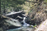
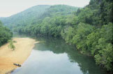 Caves,
sinkholes, and underground drainage occur, heavily influencing surficial
water availability and water temperature. Clear, cold, perennial, spring-fed
streams are common, and typically have gravelly substrates; in addition,
many small dry valleys occur. Ecoregion
39 is not as mountainous as Ecoregions 36 (Ouachita Montains) or 38
(Boston Mountains), but is higher and more rugged than Ecoregion 73
(Mississippi Alluvial Plain). Habitat diversity and species richness
is high. Soils are often cherty and have developed from carbonate rocks
or interbedded chert, sandstone, and shale; mesic Ultisols, Alfisols,
and Mollisols are common. Soil order mosaic, soil temperature regime,
and lithology are all distinct from nearby Ecoregions 36, 37, 38, and
73.
Caves,
sinkholes, and underground drainage occur, heavily influencing surficial
water availability and water temperature. Clear, cold, perennial, spring-fed
streams are common, and typically have gravelly substrates; in addition,
many small dry valleys occur. Ecoregion
39 is not as mountainous as Ecoregions 36 (Ouachita Montains) or 38
(Boston Mountains), but is higher and more rugged than Ecoregion 73
(Mississippi Alluvial Plain). Habitat diversity and species richness
is high. Soils are often cherty and have developed from carbonate rocks
or interbedded chert, sandstone, and shale; mesic Ultisols, Alfisols,
and Mollisols are common. Soil order mosaic, soil temperature regime,
and lithology are all distinct from nearby Ecoregions 36, 37, 38, and
73.
 Potential
natural vegetation is mostly oak-hickory forest. Open forest dominates
rugged areas and pastureland and hayland are common on nearly level
sites. Shortleaf pine grows on steep, cherty escarpments and on shallow
soils derived from sandstone; it becomes more common in Ecoregions
35 (South Central Plains), 36 (Ouachita Montains), and the southern
portion of Ecoregion 38 (Boston Mountains). Glades dominated by grass
and eastern redcedar are found on shallow, droughty soils especially
over dolomite.
Potential
natural vegetation is mostly oak-hickory forest. Open forest dominates
rugged areas and pastureland and hayland are common on nearly level
sites. Shortleaf pine grows on steep, cherty escarpments and on shallow
soils derived from sandstone; it becomes more common in Ecoregions
35 (South Central Plains), 36 (Ouachita Montains), and the southern
portion of Ecoregion 38 (Boston Mountains). Glades dominated by grass
and eastern redcedar are found on shallow, droughty soils especially
over dolomite.
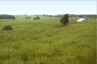
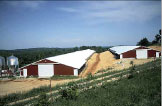 Primary
land uses are logging, housing, recreation, and, especially, poultry
and livestock farming. Water quality in the Ozark Highlands (39) is
different from the other ecoregions in Arkansas and is strongly influenced
by lithology and land use practices. Alkalinity, total dissolved solids,
and total hardness values are relatively high, reflecting the influence
of Ecoregion 39 is distinctive limestone and dolomite. Fecal coliform
and nitrite-nitrate values are elevated downstream of improved pastureland
that is intensively grazed by cattle and fields where animal wastes
from confined poultry and hog operations have been applied.
Primary
land uses are logging, housing, recreation, and, especially, poultry
and livestock farming. Water quality in the Ozark Highlands (39) is
different from the other ecoregions in Arkansas and is strongly influenced
by lithology and land use practices. Alkalinity, total dissolved solids,
and total hardness values are relatively high, reflecting the influence
of Ecoregion 39 is distinctive limestone and dolomite. Fecal coliform
and nitrite-nitrate values are elevated downstream of improved pastureland
that is intensively grazed by cattle and fields where animal wastes
from confined poultry and hog operations have been applied.
Parts of Ecoregion 39 are experiencing rapid population growth along with associated habitat alteration and water pollution. Fish communities characteristically have a preponderance of sensitive species and are usually dominated by a diverse minnow community along with sunfishes and darters.
Content provided by Woods et al. 2004.
![]()
Announcements |
AWAP in the News |
Executive Summary |
Wildlife Action Plan
Database |
Ecoregions |
Grants
|
Legislative History
|
Resources |
Partners |
Home
© 2005 Designing A Future For Arkansas Wildlife All Rights Reserved